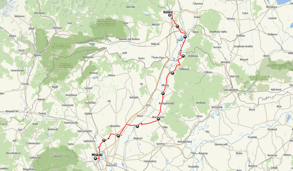
In Košice, from the RAJT at the corner of St. Elisabeth’s Cathedral Square, turn right onto Rooseveltova Street, then right at the large two-lane junction and then left at the large two-lane junction. Leave the city centre in an easterly direction on Palackého and turn right after the railway underpass, passing the petrol station. Turn off the overpass, cross the road and take the cycle path along the Hernád river. From here on, only pedestrian and cycling traffic is on the route (1.6 km from the start). Follow the cycle path along the river for 4 km, then take a right and left turn onto the cycle path on the pavements as you enter the housing estate. Returning to the Hernád river bank, follow the cycle path to the first interchange.
etap: 9,1 km, total distance: 9,1 km
After that, you turn onto the gravel and dirt fishing road along the riverbank, which is wide and of sufficient quality for a brisk run. This section has a variable, winding trail throughout, but is easy to follow as you stick to the thicker, more exiting paths along the riverbank throughout. Soon you’re completely out of the suburban settlements of Kosice and after wide meadows and fields you come to a cooperative building and turn left onto a wooden bridge. Crossing the river, we arrive at the second crossing point, on Nyzna Misla.
etap: 7,7 km, total distance: 16,8 km
When you reach the village, the road is asphalt again. A sharp right turn takes you onto the road connecting the villages in the area. After passing through Zdana and then Trstené pri Hornáde (Abaújnádas), we cross the border between the two states (both geographically and physically) and then take the uphill road to Kéked, the crossing point.
etap: 11,8 km, total distance: 28,6 km
After the interchange at kéked, turn sharp right uphill onto the 3709 road through the Hegyalján. Here, climbing along the western slopes of the Zemplén hills to Abaújvár, and then leaving the village, turn immediately left towards Telkibánya, following the cycle path towards the Ezüst-Csenkő fishing lake. Turning right here towards Gönc, we “climb” the hills before Gönc on the 3708 road, with the S-bends. In Gönc, take Kossuth Lajos street to reach the interchange.
etap: 12,6 km, total distance: 41,2 km
From the Gönc interchange, continue running, keeping left towards the railway station, until the next right turn, then turn left towards Petőfi Street. Continue along Petőfi street and turn left at the “big fork” onto Ipartelep street. Passing the railway tracks, turn right and then left on the road 3713 towards Göncruszka. After Göncruszka, we pass through the village of Vilmány and arrive in Vizsoly. The interchange is in the car park next to the Vizsoly Bible Show
Stage: 12,1 km, total distance: 53,3 km
From here we continue towards Abaújszolnok on the road we have been using so far. On the left you will see the proud castle of Boldogkőváralja, and then you arrive in Abaújkér. Here we continue straight ahead, joining the main road 39 to arrive at the interchange in the centre of Abaújszántó.
etap: 13.2 km, total distance: 66.5 km
At the southern end of Abaújszántón, turn off the main road 39, right onto the road to Pere and Halmaj. After the roundabout, leave the village and continue up a long, straight climb for kilometres. Once on the roof, you reach the upper houses of Felsődobsza, from where you descend down a steep and winding road to the village. Turn left here and follow the Hernád river to Hernádkércs, where the next turning point is.
etap: 12,9 km, total distance: 79,4 km
From here, we soon turn right towards Halmaj, crossing the Hernád river, and then passing the edge of Kiskinizs, we arrive at Halmaj. Cross the main railway line between the houses of the village and turn left onto a cycle path. This leads out to the main road 3, where we turn left and continue along the cycle path. We pass through Aszalo, and when we reach Szikszó, we turn right at the hospital onto Petőfi Sándor Street. Follow this and after a left turn you will arrive at the interchange in the town centre.
etap: 13.4 km, total distance: 92.8 km
After the Sikszo changeover point, turn sharp right onto the road leading north out of town, which will soon take you out of the village. Turn left at the fruit press onto a macadam road. Continue straight on for a long stretch, then uphill on dirt roads towards the geodesic tower. Climbing up to the summit, you descend initially along the forest edge and then on dirt roads, changing left-right-left-right, through wooded, ploughed and agricultural areas. Soon you come down to a fragmented tarmac road, where you turn right and enter the houses of Sajóvámos. Here is the last turning point.
etap: 10.0 km, total distance: 102.8 km
Continue along a road, then leave the village on the road leading west towards Szirmabesenyő. Crossing the bridge over the Sajó river, we arrive at Szirmabesenyő, where a refreshment point is set up on the road in front of the sports field, on Állomás út. From here, turn left onto Széchenyi út, then left past the houses to the flood protection dam. Leave the dam after a sharp right turn. The turn-off leads to a public road, where we cross Zsigmondy utca and turn left onto Besenyői utca. Passing under the flyover, we go straight on the pavement, crossing Kőrössy utca, between the apartment buildings of Selyemrét, and then turn right onto Bajcsy-Zsilinszky utca, where we take the pavement parallel to the tram. Continue along this street, crossing three traffic light junctions, and you will reach the pedestrian street, where you will run straight ahead to the Finish at Szent István tér.
etap: 13.5 km, total distance: 116.3 km
